
Home > Apps > Maps & Navigation > スーパー地形 - GPS対応地形図アプリ

| App Name | スーパー地形 - GPS対応地形図アプリ |
| Developer | kashmir3d |
| Category | Maps & Navigation |
| Size | 16.7 MB |
| Latest Version | 4.6.17 |
| Available on |
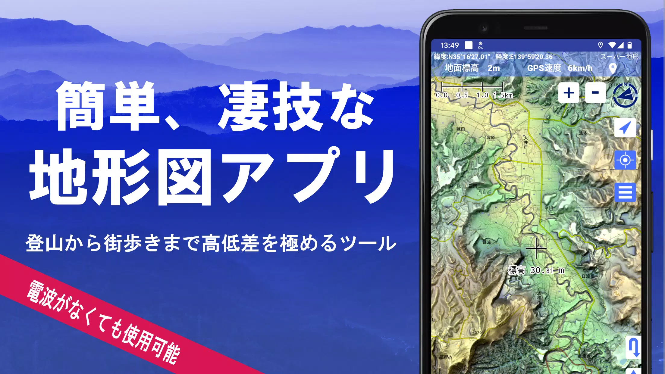
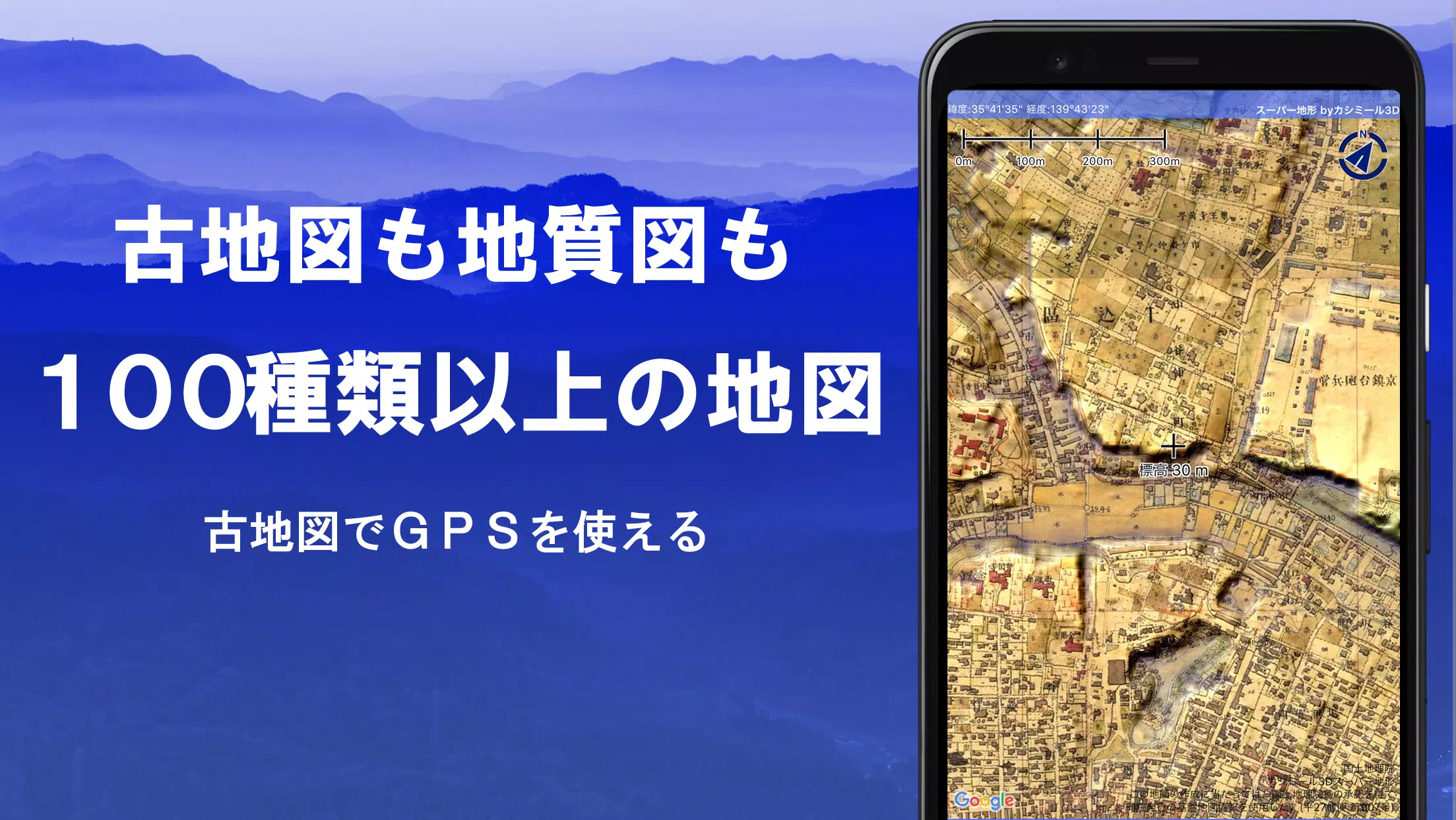


With over 100 types of maps at your fingertips, including those from the Geographical Survey Institute, the Super Terrain app offers an unparalleled navigation experience. Whether you're scaling mountains or strolling through urban landscapes, these maps help you make the most of elevation differences, enhancing your outdoor adventures. The app proudly received the 2018 Japan Cartographic Society Award for Best Work, a testament to its innovative mapping capabilities.
Leverage the app's "super terrain data" for a detailed terrain perspective, thanks to its unique technology. You can access a variety of maps from the Geospatial Information Authority of Japan, including topographic, geological, historical, and prewar Ordnance Survey Department maps. The GPS function allows you to record tracks and manage GPX logs, making it perfect for navigation, mountain climbing, and urban exploration. Features like GPS navigation with audio support, data recording, and editing further enhance your outdoor experience.
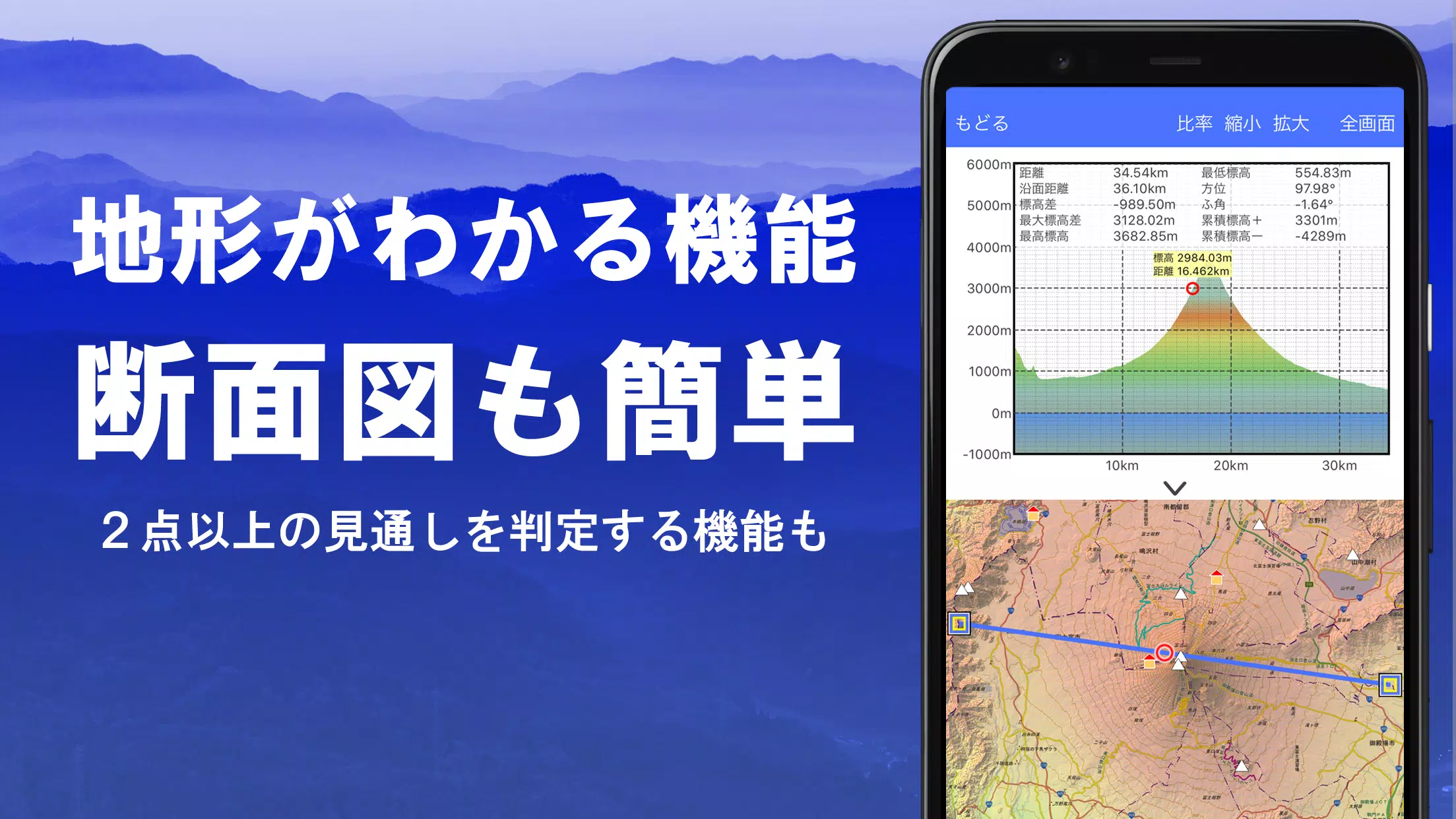
The app includes a visibility determination function for creating cross-sectional diagrams, useful for observation and radio communication, and can even display buildings. Enjoy a 360° panoramic view to identify mountains, and see the sun, moon, and GPS points. With offline capabilities like bulk map downloads and a map cache function, you're well-equipped for adventures in areas without radio signals. You can also associate photos with specific points, display contour lines from elevation data, and show MGRS grids.
For those interested in GIS data, the app supports reading, displaying, and editing from GeoJSON files, and you can draw shapes. It's versatile enough for use overseas, with options for map printing and PDF output, and it supports a dark theme for better visibility in various conditions.
A Wealth of Maps at Your Disposal
The Super Terrain app boasts an extensive collection of over 100 map types, including our proprietary super topographic data and maps from the Geospatial Information Authority of Japan. Note that aerial photographs may not be available for all locations, with the "latest" and "around 1974" categories offering broader coverage. You can use maps with super terrain data for free for the first 5 days after installing the app.
Creating Cross Sections and Outlooks
Easily draw cross sections through any point on the map, and utilize the visibility judgment function to account for Earth's curvature and atmospheric differences. This feature is invaluable for route planning during climbs, assessing wireless visibility, and understanding terrain. Where PLATEAU building data is available, you can include buildings in your cross-sectional views.
Elevation Palette Function
Customize your map's background color with the elevation palette function, allowing you to set your preferred color gradient in 1cm increments.
Panoramic View
Experience panoramic observation maps that display mountain names from any location on the map. The 360° panorama links with your smartphone's compass, making mountain identification a breeze. You can also view the sun and moon, including moon phases, which is perfect for spotting Diamond Fuji and Pearl Fuji. Additionally, you can see GPS points and draw panoramic views of mountains abroad.
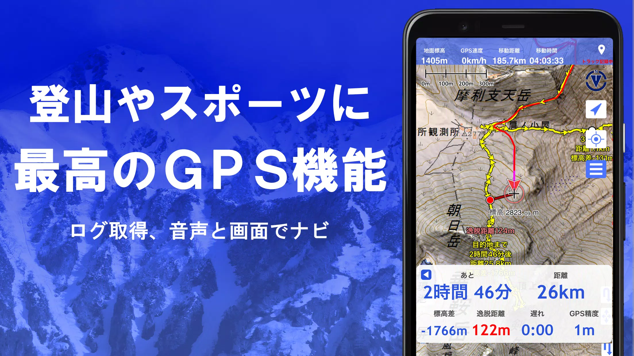
GPS Function
Utilize your smartphone's GPS to obtain location information and record tracks. The app's high-precision positioning is ideal for serious mountain climbing and outdoor activities. Display recorded tracks graphically with parameters like elevation, speed, time, and elapsed time. The point alarm function alerts you with voice and sound when you approach a designated point. You can also display photos linked to specific points and send the map center position to NaviCon.
GPS Track Summary Playback
Replay your track logs in one go, with the app automatically displaying photos taken at corresponding times. An icon marks the photo location, which you can view by tapping.
GPS Navigation Function
Navigate along preset tracks with the Track Navi function, which alerts you with voice or sound if you deviate from the path, ensuring you stay on course during climbs. The app also supports route navigation for urban walks and point navigation for targeting specific locations.
GPS Data Editing Function
Manage GPS-related point, route, and track data, organized in folders and displayed in an easy-to-read tree format. Create tracks directly on the map and import or export data in GPX format from mountain climbing sites.
Map Usage Outside the Service Area (Offline)
Use maps even in areas without signals, thanks to the bulk download function that allows you to download all scale maps for a specified area. The cache function ensures you always have access to your maps.
Map History Function
The app remembers locations you've viewed, allowing you to return to them easily.
Custom Map Compatibility
Import and use custom maps created with Kashmir 3D's map cutter, including your own maps and scanned images. When using the map cutter, divide images into approximately 256 x 256 pixels and send the resulting kmz file to Super Terrain via email or Cloud Drive.
GeoJSON Compatibility
Display and edit points, linestrings, and polygons from GeoJSON files, and draw new shapes.
Print/PDF Output
Print any map area at a specified scale or create a PDF.
Cooperation with Other Apps
Input and output GPS data in GPX, KML, and GDB formats, allowing data exchange with other apps, Kashmir 3D on your PC, and trajectory data from mountain climbing sites.
Backup Function
Back up all app data (excluding cached maps) and remove it from your smartphone. You can restore data even if you delete the app or if your smartphone malfunctions. An automatic backup feature using Google Drive ensures your data is always up to date. For detailed instructions, please refer to the manual.
About Billing Function
Some features, such as maps using super terrain data, GPS track functions, and cross-sectional views, require in-app purchases. After payment, the number of search results for place name searches increases.
●Fees: Annual payment of 780 yen/year.
●Free Trial: Enjoy a 5-day free trial after first installing the app. After 5 days, some features and maps will no longer be available unless you make a purchase. You will not be charged unless you perform a purchase operation. To purchase, select [Settings] - [Purchase to remove functional restrictions] within the app.
●Confirmation and Cancellation: Check or cancel automatic updates by opening Google Play, selecting "Regular Purchase" from the menu, and choosing "Super Terrain."
●Price Revision: Prices may change due to future feature enhancements. It's advantageous to purchase early.
Terms of Use
The copyright holder and developer are not responsible for the results of using this application. When you first start GPS, you'll be prompted to allow location services. Continuous GPS use can drain your battery, so if your device is used for emergency communication, carry a spare battery. An easy-to-understand explanation of the navigation function is available in PDF format at https://www.kashmir3d.com/online/superdemapp/superdem_navi.pdf. Note that some smartphones may interrupt or fail to record tracks due to power-saving features that close background apps. Turning off the screen while using Super Terrain may help, but it's not a permanent solution.
-
TrailBlazer123Mar 10,26Great app for hiking enthusiasts! The detailed topographic maps are super accurate and the zoom feature works smoothly. I used it on a recent mountain trek and it saved me from getting lost. Only wish the offline mode was a bit faster. 4.5 stars! 🏔️Galaxy S23
-
 Sonic Racing: CrossWorlds Characters and Tracks Revealed for Upcoming Closed Network Test
-
 Marvel Rivals Season 1 Release Date Revealed
-
 Honkai: Star Rail Update Unveils Penacony Conclusion
-
 Announcing Path of Exile 2: Guide to Sisters of Garukhan Expansion
-
 Ubisoft Cancels Assassin's Creed Shadows Early Access
-
 Best Model Kits for Adults in 2025: Ultimate Guide